There are landmarks that shout history—town halls, statues, ornate stations – and then there are the quieter witnesses: such as a lowly road bridge over a ribbon of rail that we may walk or drive our cars over regularly without a second glance – known to the early Concord settlers and locals as The Cattle Bridge.
Now, unremarkable in appearance and as nothing more than a part of Transport for NSW‘s road overbridge networks, it carries a heavy load of local memory: livestock, industry, and even childhood adventures along the margins of North Strathfield. Despite its local folklore, there has appeared to be little to no published detail (at least in commonly available sources) about why the bridge was called The Cattle Bridge by the locals (including my own grandparents and parents).
History of the bridge
The Great Northern Railway line opened in 1886. Now the T9 Northern Line, it was originally known as the Homebush to Waratah railway line from Sydney to Hornsby. The North Strathfield railway station wasn’t to be built until 1918. The bridge over the railway line (north of where the station was later to be built) was built as part of the original 1886 railway corridor project. The bridge was built between two portions of Stephen Burr’s 25-acre land grant. By the time the railway was built, Burr’s grant was part of the holdings of Thomas Walker, and later part of his estate. The roads went in after the subdivision (around 1908) and used the pre-existing crossing.
An article about the opening of the rail line from the Friday, 17th September 1886 edition of the Sydney Morning Herald describes the overhead bridge and bridge structures as follows:
“There are 11 overbridges, all built of timber on brick piers…” and “There is an overbridge at 8 miles 25 chains.” It also notes in this newspaper article, “A 12-feet timber opening has been provided at 10 miles 48 chains to serve as a passage for cattle”.
John Johnson, Local Studies Librarian from Canada Bay Library & Community Services, commented that from this article (and other early maps), the Beronga Street bridge is noted as a little past the 8 ¼ mile point. A quarter mile, he said, is “20 chains”, so 8 miles 25 chains (from Sydney) would be the approximate location of the bridge. In today’s speak, that’s about 13.28 kilometres. He also identified that the “…12 feet (or 3.65 metres) timber opening provided at 10 miles 48 chains to serve as a passage for cattle”, is the one that was north of Rhodes Station, near Rhodes House, not the Beronga Street overbridge.
When this fact came to light, my research almost stopped because it was thought that this may have been the bridge that was being referred to by locals, and not the Beronga Street overbridge. There was nothing further coming up in the records, yet the burning question remained…
Why is the overbridge called the ‘Cattle Bridge’?
The simplest explanation is often the truest: oral histories recall cattle and livestock being driven or moved in the general vicinity toward the abattoirs and stockyards in the early 20th century, and as a result of that, the bridge’s colloquial name stuck. However, concrete documentary proof of livestock being herded over that exact span is almost non-existent in digitised records, but the name is well-attested to in community memories, and there are references to it by locals in the Canada Bay Heritage Society newsletters and blogs.
On 17th July 1923, the Municipality of Concord’s Town Clerk published a Notice in the NSW Government Gazette under the Local Government Act 1919, Ordinance 60, about “Driving Loose Animals”.
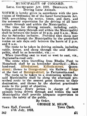
This notice prescribed the specific routes, times, days, and necessary supervision for the driving of all loose animals, including cattle, horses, and sheep, through and within the municipality.
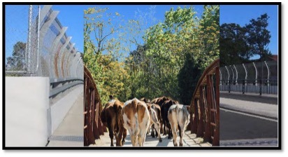
In short, the designated route when moving loose animals from Rhodes Punt to Homebush, included Blaxland Road, Alfred Street, Killoola Street, Queen Street, “…thence to George Street, via Railway Bridge at the foot of Beronga Street, to Parramatta Road”. Mystery solved. The bridge was in fact used as a gazetted livestock route, hence the locals dubbed it “The Cattle Bridge”.
The Cattle Bridge was replaced by the current road bridge between 1966 and 1970.
So why should we preserve the story of a small bridge?
Conservation isn’t only about ornate facades; it’s about the everyday infrastructure that framed daily life. The Cattle Bridge is shorthand for a time when North Strathfield, Concord and the wider Canada Bay area was more rural and industrial — brickworks, abattoirs, and rail-led commerce — and much less suburban. Recording the bridge’s name, uses, and the memories attached to it helps to complete the picture of the community in transition. The bridge currently has no formal name…perhaps it will become officially known as The Cattle Bridge in the future…
Graphic showing the overhead cattle bridge and the ‘site for future railway platform’ (North Strathfield Station) when the subdivision land was being sold by the Walker Estate. Source: State Library of NSW
This research was a team effort – a very big thanks to John Johnson, Local Studies Librarian, City of Canada Bay – Library & Community Services, and Sally Jerapetritis, Secretary of the City of Canada Bay Heritage Society.
Leonie Latimer
Sources:
Trove – Sydney Morning Herald 17 September 1886 (accessed 20/9/2025): (https://trove.nla.gov.au/newspaper/article/13635742?searchTerm=timber%20bridge%20over%20railway%20at%20north%20strathfield)
Trove – NSW Government Gazette September 1923 (accessed 20/09/2025): https://trove.nla.gov.au/newspaper/article/219902891?searchTerm=beronga%20street%20bridge
Graphics: FreePik (cow herd photo) overlaid on a recent photo of the existing bridge.


